

Conservation International’s (CI) video about their work in the Abrolhos Seascape. Field Chronicles is a series where each episode showcases successful CI programs. This episode presents CI’s work in expanding marine protected areas in Abrolhos, Brazil, home of the greatest concentration of marine life in the South Atlantic. The focus is on the extreme challenges CI’s marine team faced, and how they overcame them through community involvement and amplification. This episode also is a good example of CI’s new mission in action as promoting green economies is key to the CI team’s strategy. Also featured is the discovery of the largest rhodolith beds in the world- an area the size of El Salvador!
Tag: maerl beds
The Griffith Geoscience Programme is administered by the Geological Survey of Ireland (GSI) as part of Ireland’s National Geoscience Strategy and was established by the Department of Communications, Energy and Natural Resources in 2007. The scheme honours the memory of Richard Griffith (1784-1878), the celebrated geologist and engineer. The project uses data obtained as part of the INFOMAR programme, with the use of Ireland’s National research vessels, the Celtic Explorer and the Celtic Voyager. Galway Bay is one of INFOMAR’s 26 selected priority bays, as the INFOMAR project now focuses on mapping Ireland’s shallow water regions.
As part of my PhD research, last week I was invited to speak at the Geological Survey of Ireland in Dublin for the “Griffith Research Jam.” This was an event where researchers and postgraduates funded by the Griffith Geoscience Research Award had the opportunity to present their research and share findings. Researchers came from all four provinces around Ireland including from National University of Ireland, Galway, Queens University Belfast, University College Dublin, University College Cork, Trinity College Dublin and some industry representatives. Here is my presentation entitled “Sediment Mobility Modelling and Benthic Disturbance of Maerl Habitats,” (Siddhi Joshi, Garret Duffy et. al. 2012) The web version of the slides can be accessed below.
References
Siddhi Joshi, Garret Duffy, Martin White and Colin Brown, 2012, Sediment Mobility Modelling and Benthic Disturbance of Maerl Habitats, Oral Presentation, Griffith Research Jam, Geological Survey of Ireland, Dublin.
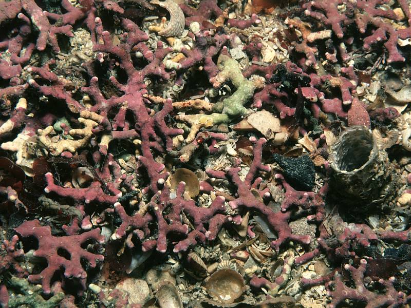
What is Maërl?
![]()
Maërl refers to a group of free-living coralline red algae belonging to the Class Rhodophyta. The term “Maërl” is a Breton term with there even being a festival about maerl in Brittany. Maërl beds form a complex three-dimensional habitat and have been found to harbour greater diversity of life in comparison to surrounding habitats. As a result they are protected under the EU Habitats Directive, with two maërl forming species, Phymatolithon calcareum (Pallas) W.H.Adey & D.L.McKibbin, 1970., Lithothamnion corallioides (P.L.Crouan & H.M.Crouan) P.L.Crouan & H.M.Crouan, 1867, found in under Annex V. In many cases, maërl is also given protection under Annex 1 of the EU Habitats directive as a sub-feature habitat and as an indicator of a biodiversity hotspot.
Distribution of maërl in the British Isles- NBN Map- Phymatolithon calcareum Common Maërl

Biogenic Beach Sediments
Biogenic gravel beaches made of dead or fossil maërl deposits can be found adjacent to live maërl habitats.

Many different growth forms result in different grain shapes of the thalli.

Intertidal Maërl
Muckinish Bay in County Clare has maerl beds which are only exposed during the low spring tide.

Subtidal Maërl
Subtidally, maërl free living and forms branches
Maërl megaripples
Where currents are strong enough, or due to disturbance due storm-waves, maërl megaripples can form (asymmetric for currents-formed ripples and symmetric wave-formed ripples) Here is some rare footage of maerl mega ripples in Northern Ireland:
Image credits
(1) Maërl beds in the Fal Estuary with harbour crab – Liocarcinus depurator: Image credit to Ross Bullimore
(2) Trá an Doilín, Ireland Seabed Habitats
(3) Phymatolithon calcareum, Image credit to Malcolm Storey www.bioimages.org.uk
(4) Muckinish Bay, County Clare, Image credit to Seabed Habitats
(5) Maërl Megaripples, Diver footage courtesy of Joe Breen of the Northern Ireland Environment Agency (NIEA)
A big thank you to those of you who voted in the Seabed Habitats opening poll! As a first time blogger, it has really helped me to get a better idea of the audience. And the results are:

In first place: Maerl Beds (with 41.67%)
Joint second: Rocky Shores, Mangroves and Extreme Environments (all with 16.67%)
Third place: Cold water Corals (with 8.33%)

Hence, I am currently preparing the post on maerl beds (which will be with you very shortly!) Meanwhile, enjoy the following video about maerl in French as an introduction to the subject :
Le maërl des Îles Glénan from Rade-de-Brest Bretagne.Vivante on Vimeo.
Location of video: Réserve Naturelle Saint-Nicolas-des-Glénan- an archipelago South East of Brest, Finistère, Brittany, France
Image Credit to Keith Hiscock, Marine Biological Association of the UK (MBA), published on the MarLIN website
(Rotating annular flume)
