Monitoring Earthquakes from in the Classroom

This year, at the Irish Geological Research Meeting (IGRM) in Derry, I saw a presentation which quite amazed me. It was about the Seismology in Schools project, made by Emily Neenan of the Dublin Institute for Advanced Studies (DIAS). This is an international programme, which in Ireland is run by DIAS. Following this presentation, I found out more about the scheme:

What is the Seismology in Schools project?

The Seismology in Schools project is an outreach programme introduced by the Dublin Institute for Advanced Studies to schools around Ireland. School children have the opportunity to make real measurements of earthquakes happening around the world from their own classroom. Students monitor the performance of the seismometer daily and consolidate the learning and data collection techniques outlined in the training days. Students upload the recorded earthquake data to the “IRIS Seismographs in Schools” website to share with other schools in Ireland, UK and USA.

The experience of the project has been that learners become more engaged when they see how earthquakes happen in reality and also learn about them through the media. They gain an understanding of earthquake hazards around the world and reflect upon what can be done by scientists and engineers to mitigate the devastating effects of big earthquakes.

What is a seismometer and how does it measure earthquakes?

A seismometer is a very sensitive instrument that can detect movements of the Earth’s surface. The type of seismometer used in the scheme is an SEP seismometer, available from Mindset instruments (for UK and Ireland). The SEP Seismometer System uses the same basic principle underlying all seismometers, which is that of inertia. Seismic waves from an earthquake make the ground move relative to the recording device. In the case of the SEP seismometer, there is a large mass on the end of a boom: this stays where it is as the ground moves beneath the seismometer, and this relative movement is recorded.
SEPseismometer
Please would you give us a quick example of a recently recorded earthquake.

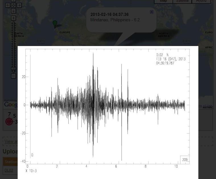
For example, there was a recent earthquake of 6.2 on the Richter scale at Mindanao, Philippines in February, which was recorded by a school in Ireland, using their seismometer. The school processed these data and subsequently uploaded to the IRIS website:

SIS

How many schools are involved in the scheme?

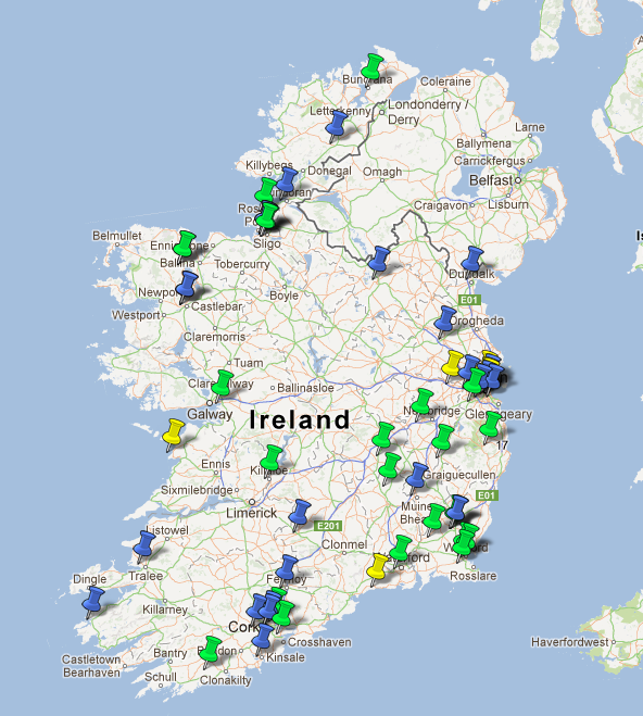
Currently there are 55 Irish primary and secondary schools in the programme and this has now been extended to include colleges, universities and geo-parks. Internationally, there are over 448 schools participating in this scheme, in UK, USA and Ireland. If you know a school which would like to get involved or are a teacher or educator please see the useful links below and get in touch with IRIS (USA), DIAS (Ireland) or the BGS (UK) via their “Contact forms”.

A map of the schools participating in the Seismology for schools project in Ireland.
A map of the schools participating in the Seismology in Schools project in Ireland.

Useful Links

Dublin Institute for Advanced Studies Seismology In Schools website (Ireland) with IRIS Contact form or by emailing Emily Neenan (eneenan*atsign*cp.dias.ie)
IRIS Seismographs In Schools  website (USA) with IRIS Contact form
British Geological Survey School Seismology project website  (UK) with  BGS Contact form
Mindset seismometers  website

Acknowledgements

Thank you to Emily Neenan of the Dublin Institute of Advanced Studies, Ireland, for information used as part of this blog post. It has helped us learn about a unique outreach programme, which can potentially inspire the younger generation to study the geosciences plus make us all more earthquake aware!! Happy St Patrick’s Day.

Farraigí na hÉireann

http://vimeo.com/26162950

Farraigí na hÉireann is an Irish marine science documentary currently being broadcast on TG4, Ireland’s Irish language TV channel. Almost two years in the making, this is the first Irish Ocean wildlife series to be broadcast and is very unique in that it was predominantly filmed underwater around Ireland. Farraigí na hÉireann was produced entirely in Ireland for TG4 by independent Irish production company Sea Fever Productions from Lahinch in Co. Clare. TG4 are showing ‘Farraigí na hÉireann’ on Tuesday. Feb. 19th at 8pm and then the same time every week for six weeks. Tonight it is the second episode about the seabed! You can watch it on the TG4 Player under the “documentaries” tab, if it is available in your country.

Virtual dive in the Great Barrier Reef

Heron Island is a coral cay located near the Tropic of Capricorn in the southern Great Barrier Reef, 72 km north-east of Gladstone, Queensland, Australia, and 539 km north of the state capital Brisbane. The island is situated on the leeward (western) side of Heron Reef, a fringing platform reef of significant biodiversity, supporting around 900 of the 1,500 fish species and 72% of the coral species found on the Great Barrier Reef (Wikipedia).

Google have partnered with The Catlin Seaview Survey, a major scientific study of the world’s reefs, to make these amazing images available to millions of people through the Street View feature of Google Maps. The Catlin Seaview Survey used a specially designed underwater camera, the SVII, to capture these photos.  For further views please see the Google Street view Ocean gallery. For more information about the Catlin Seaview Survey please view their website.

An cúpla focal

Nollaig Shona Daoibh!

Irish_clover02

Dia daoibh! Just though I would test my Irish a bit- Merry Christmas!!

Tá me ag staidéar sa grinneall na farraige in Cuan na Gaillimhe agus an dríodar muirí. Rinne rialtas na hÉireann mapáil bataiméadrach na hAtlantach. Déanann mé mapa gnathóg. Is féidir linn ag staidéar gealaíocht mhuiri agus sa beantós. Chuaigh mé go dti domhainfharraige in aistear mara anuraidh. Chruinnigh coiréalach agus ag staidéar geomorfeolaíocht. Iniaíonn staidéar ar cgóstaí ag foghlaim cén chaoi múnlaigh tonn sa Trá an Doilín in An Cheathrú Rua agus ag staidéar aigéaneolaiocht na chuain le linn stoirmeacha. Tá me ag staidéar an Dioplóma sa Ghaeilga go páirtaimseartha agus is maith liom an cúrsa. Foghlaimím go leor frásaí nua gach seachtain sa rang Gaeilge agus níl bréag ar bith ansin tá se doiciúil. Caithim a lán ama ag obair gach lá. Bíonn muid an-ghnóthach gach seachtain agus táimid faoi bhrú ach is brea liom é!

Translation from the Irish: An cúpla focal– A couple of words

Tá me ag staidéar sa grinneall na farraige in Cuan na Gaillimhe agus an dríodar muirí.
I am studying the seabed of Galway Bay and the marine sediments.

Rinne rialtas na hÉireann mapáil bataiméadrach na hAtlantach.
The Irish government have done bathymetric mapping of the Atlantic.

Déanann mé mapa gnathóg.
I make habitat maps.

Is féidir linn ag staidéar gealaíocht mhuiri agus sa beantós.
We are able to study marine geology and the benthos.

Chuaigh mé go dti domhainfharraige in aistear mara anuraidh.
I went to the deep sea in a sea voyage last year.

Chruinnigh coiréalach agus ag staidéar geomorfeolaíocht.
We collected coral and studied geomorphology.

Iniaíonn staidéar ar cgóstaí ag foghlaim cén chaoi múnlaigh tonn sa Trá an Doilín in An Cheathrú Rua agus ag staidéar aigéaneolaiocht na chuain le linn stoirmeacha.
I study coastal science learning how waves shape the Trá an Doilín beach at Carraroe and study the oceanography of the bay during a storm(?)

Tá me ag staidéar an Dioplóma sa Ghaeilga go páirtaimseartha agus is maith liom an cúrsa.
I study for the Diploma in Irish on a part-time basis and I like the course.

Foghlaimím go leor frásaí nua gach seachtain sa rang Gaeilge agus níl bréag ar bith ansin tá se doiciúil.
We learn lots of new phrases each week in the Irish class and it is no lie that it is difficult.

Bíonn muid an-ghnóthach gach seachtain agus táimid faoi bhrú ach is brea liom é!
We are very busy all week and we are under pressure but I love it!

Christmas Day Swim

A Winter Sunrise at Salthill, GalwaySpending Christmas in Ireland this year, I am going to be taking part in the COPE Galway Christmas Day Swim at Black rock, Salthill, Galway. COPE Galway is a local Galway charity that provides services to those isolated in our community – including sustenance and social supports for older people, a refuge for women and children affected by domestic violence and accommodation for men and women experiencing homelessness. The COPE Galway Christmas Day Swim will take place, as usual, on December 25th at Blackrock, Salthill from 10am-1pm. This year we are aiming to beat the world record set last year  for the largest amount of people swimming in Santa Hats on Christmas Day. Please sponsor me at the following link http://www.mycharity.ie/event/siddhi_joshi_Christmasdayswim/ 

Here is a video of last year’s event in Galway: Chilly!!

Griffith Research Jam Talk

maerl

The Griffith Geoscience Programme is administered by the Geological Survey of Ireland (GSI) as part of Ireland’s National Geoscience Strategy and was established by the Department of Communications, Energy and Natural Resources in 2007. The scheme honours the memory of Richard Griffith (1784-1878), the celebrated geologist and engineer. The project uses data obtained as part of the INFOMAR programme, with the use of Ireland’s National research vessels, the Celtic Explorer and the Celtic Voyager. Galway Bay is one of INFOMAR’s 26 selected priority bays, as the INFOMAR project now focuses on mapping Ireland’s shallow water regions.

As part of my PhD research, last week I was invited to speak at the Geological Survey of Ireland in Dublin for the “Griffith Research Jam.” This was an event where researchers and postgraduates funded by the Griffith Geoscience Research Award had the opportunity to present their research and share findings. Researchers came from all four provinces around Ireland including from National University of Ireland, Galway, Queens University Belfast, University College Dublin, University College Cork, Trinity College Dublin and some industry representatives. Here is my presentation entitled “Sediment Mobility Modelling and Benthic Disturbance of Maerl Habitats,” (Siddhi Joshi, Garret Duffy et. al. 2012) The web version of the slides can be accessed below.


References

Siddhi Joshi, Garret Duffy, Martin White and Colin Brown, 2012, Sediment Mobility Modelling and Benthic Disturbance of Maerl Habitats, Oral Presentation, Griffith Research Jam, Geological Survey of Ireland, Dublin.